+386 1 292 73 90info@geavis.si
SI
logo
Geavis
logo
  • Services
    • Spatial Data Acquisition
    • Advanced Spatial Data Processing
    • Geospatial Analysis
    • Visualizations and Presentations
  • Applications
    • Governmental Institutions and Public Sector
    • Real Estate
    • Mapping and Land Surveying
    • Civil Engineering
    • Industry and Infrastructure
    • Quarries and Open Mines
    • Agriculture and Forestry
    • Insurance
    • Spatial Research
    • Tourism and Promotion
  • Technology
  • Projects
  • Geavis
    • Geavis
    • Clients
    • Contact
  • Blog
How various methods of data capture produce different point clouds
Geavis is one of the first in Slovenia with the CAA certificate of expertise in the rules of flying unmanned aircraft systems
The importance of georeferencing raster images
12.07.2016 Technology

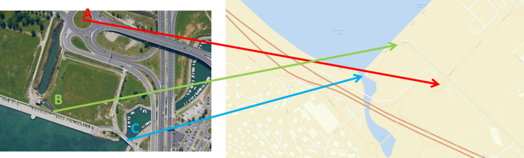
The images of the Earth’s surface taken with a satellite or an aircraft (satellite images, aerial photos etc.) are ordinary digital photos that lack the information on how the areas on the photo correspond to the locations on the Earth’s surface. Without location information, these raster images cannot be used for analyses or comparisons with other spatial data. The photos must first be entered into the National Coordinate System. This is called georeferencing, whereby each point on the digital image is determined coordinates within the National Coordinate System. Once we know the coordinates of points on the image, we can place the image precisely over the chart so that the points on the image match those on the chart. The data obtained by remote sensing can thus be compared, analysed and integrated with other spatial data sources.

Georeferencing is a necessary step prior to the processing of spatial data; there are different methods used directly following the spatial data capture. A frequently used method is based on the use of ground control points, i.e. points on the terrain with known coordinates and which are recognisable in the photo. We can use the coordinates of several control points to calculate coordinates of all other points in the photo.

Geavis-georeferenciranje1

Geavis-georeferenciranje2


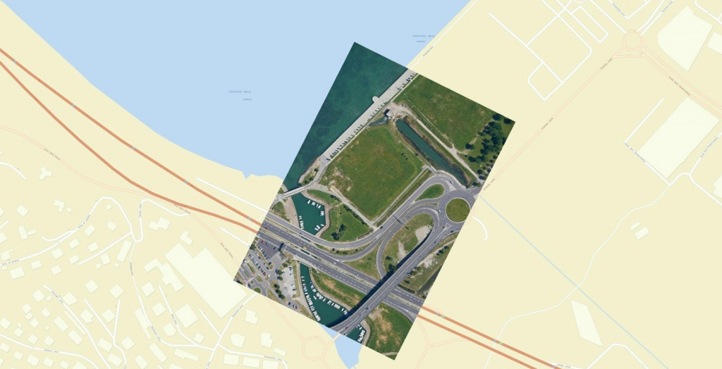
Precise georeferencing is a complex task and depends on several factors, i.e. the quality of devices used to capture images, shooting altitude, terrain type and incline, transformation between coordinate systems, levelling methods etc. Contemporary aerial photography systems achieve the georeferencing precision in terms of position and altitude of 1–2 pixels. If, for example, GSD=5 cm, the anticipated georeferencing precision is 5–10 cm.

3 Like!
Share
Leave a reply Required fields are marked *

Click here to cancel reply.

Categories

  • Agriculture and Forestry (4)
  • Mapping and Surveying (2)
  • Public Sector (1)
  • Quarries and Open Mines (2)
  • Real Estate (3)
  • Regulations (5)
  • Spatial Research (2)
  • Technology (40)
  • Trends (13)

Archive

  • January 2019 (1)
  • September 2018 (2)
  • June 2018 (1)
  • March 2018 (1)
  • January 2018 (2)
  • December 2017 (1)
  • September 2017 (1)
  • June 2017 (1)
  • May 2017 (2)
  • April 2017 (1)
  • March 2017 (1)
  • February 2017 (1)
  • January 2017 (3)
  • December 2016 (1)
  • November 2016 (1)
  • October 2016 (1)
  • September 2016 (2)
  • August 2016 (1)
  • July 2016 (2)
  • May 2016 (2)
  • April 2016 (1)
  • February 2016 (2)
  • January 2016 (1)
  • December 2015 (1)
  • November 2015 (1)
  • October 2015 (1)
  • September 2015 (2)
  • August 2015 (1)
  • July 2015 (2)
  • May 2015 (1)
  • April 2015 (1)
  • March 2015 (2)
  • February 2015 (3)
  • January 2015 (4)

GEOSPACE

Geospace is Geavis' collection of domestic and foreign web contents describing the adventures of those small civil unmanned drones, the application aspects of aerial photography and geospatial challenges for the benefit of life and business.


View my Flipboard Magazine.

Follow us

LinkedINYouTubeskype

BE INFORMED


We will not spam! Ever! You can unsubscribe any time.
© 2016 Geavis d.o.o.
  • | Cookies Information
  • | Legal Information
  • | Authors
Geavis