+386 1 292 73 90info@geavis.si
SI
logo
Geavis
logo
  • Services
    • Spatial Data Acquisition
    • Advanced Spatial Data Processing
    • Geospatial Analysis
    • Visualizations and Presentations
  • Applications
    • Governmental Institutions and Public Sector
    • Real Estate
    • Mapping and Land Surveying
    • Civil Engineering
    • Industry and Infrastructure
    • Quarries and Open Mines
    • Agriculture and Forestry
    • Insurance
    • Spatial Research
    • Tourism and Promotion
  • Technology
  • Projects
  • Geavis
    • Geavis
    • Clients
    • Contact
  • Blog
Why are GCPs needed in photogrammetry?
Archaeological heritage from the air
What UAV to choose? Fixed wing or rotary drone?
02.01.2016 Technology

While until not so long ago drones were mainly used in the domains of military industry and miniature enthusiasts, they have now become becoming part of our everyday life. The key issue in the project preparation is choosing either a fixed wing drone (airplane), or a drone featuring (one or more) rotor blades.Letalnik-en
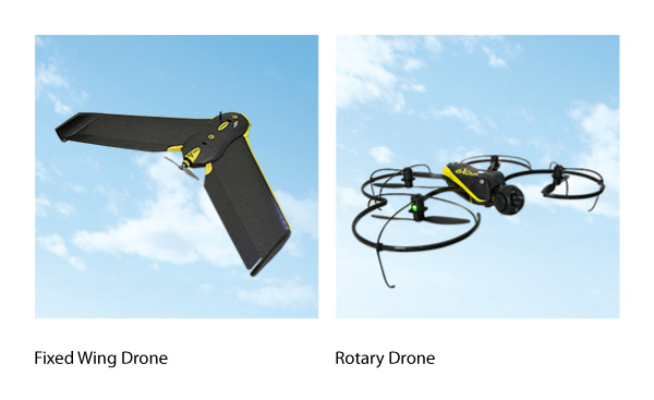
Which type of drone you choose depends on how you intend to use it. For this purpose, answer the following questions:

  • How large is your area of observation?
  • What is the structure of this area?
  • What object resolutions do you want to achieve?
  • In what weather conditions do you want to use it?
  • How much landing space do you have available?

The table below explains the core differences between what a fixed wing drone and a rotary UAV have to offer:

Fixed Wing Drone Rotary Drone
Applications land surveying (rural)
agriculture
GIS
quarries and open mines
environmental management
construction
inspection and monitoring
real estate
land surveying (urban)
construction
emergency response
media
Cruising Speed high low
Coverage large small
Object Resolution cm/px mm/px
Take-off / Landing Area large very small
Flight time long short
Wind Resistance high low

1 Like!
Share
Leave a reply Required fields are marked *

Click here to cancel reply.

Categories

  • Agriculture and Forestry (4)
  • Mapping and Surveying (2)
  • Public Sector (1)
  • Quarries and Open Mines (2)
  • Real Estate (3)
  • Regulations (5)
  • Spatial Research (2)
  • Technology (40)
  • Trends (13)

Archive

  • January 2019 (1)
  • September 2018 (2)
  • June 2018 (1)
  • March 2018 (1)
  • January 2018 (2)
  • December 2017 (1)
  • September 2017 (1)
  • June 2017 (1)
  • May 2017 (2)
  • April 2017 (1)
  • March 2017 (1)
  • February 2017 (1)
  • January 2017 (3)
  • December 2016 (1)
  • November 2016 (1)
  • October 2016 (1)
  • September 2016 (2)
  • August 2016 (1)
  • July 2016 (2)
  • May 2016 (2)
  • April 2016 (1)
  • February 2016 (2)
  • January 2016 (1)
  • December 2015 (1)
  • November 2015 (1)
  • October 2015 (1)
  • September 2015 (2)
  • August 2015 (1)
  • July 2015 (2)
  • May 2015 (1)
  • April 2015 (1)
  • March 2015 (2)
  • February 2015 (3)
  • January 2015 (4)

GEOSPACE

Geospace is Geavis' collection of domestic and foreign web contents describing the adventures of those small civil unmanned drones, the application aspects of aerial photography and geospatial challenges for the benefit of life and business.


View my Flipboard Magazine.

Follow us

LinkedINYouTubeskype

BE INFORMED


We will not spam! Ever! You can unsubscribe any time.
© 2016 Geavis d.o.o.
  • | Cookies Information
  • | Legal Information
  • | Authors
Geavis