+386 1 292 73 90info@geavis.si
SI
logo
Geavis
logo
  • Services
    • Spatial Data Acquisition
    • Advanced Spatial Data Processing
    • Geospatial Analysis
    • Visualizations and Presentations
  • Applications
    • Governmental Institutions and Public Sector
    • Real Estate
    • Mapping and Land Surveying
    • Civil Engineering
    • Industry and Infrastructure
    • Quarries and Open Mines
    • Agriculture and Forestry
    • Insurance
    • Spatial Research
    • Tourism and Promotion
  • Technology
  • Projects
  • Geavis
    • Geavis
    • Clients
    • Contact
  • Blog
What is the difference between ‘accuracy’ and ‘precision’?
Why phenomena of Ghosting and Motion Blur occur in photogrammetry
What checks and calibrations are required for unmanned aerial vehicles?
10.09.2017 Technology

To ensure operational reliability, flight safety and the quality of captured geospatial data with an unmanned aerial vehicle, careful monitoring of the aircraft condition and professional calibration of the entire device as well as its individual parts are required. Geavis’s unmanned aerial vehicles are factory-checked and calibrated at the time of manufacture and at each service, including:

  • temperature calibration of autopilot (barometer, pressure sensor, gyroscope & accelerometer are tested in a climatic chamber)
  • IMU calibration of gyroscope & accelerometer
  • current calibration of motor power supply by autopilot
  • servo & trim calibration
  • in-air pitot calibration (testing of air speed values)

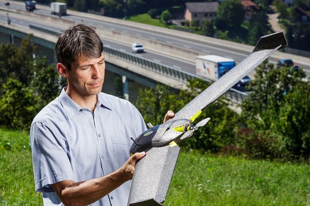
Prior to each aerial survey, the aerial vehicle operator performs a pre-flight inspection to check carefully the status of the aircraft and make sure that it is tightly assembled and functioning properly. The inspection includes a careful inspection of the hull, wings, electrical components, engine, propeller and its attachment, steering surfaces, antennae, pitot-static system and also the voltage of the battery. Additionally, it also takes into account that the aircraft must be outdoors at least 10 minutes before the flight, in order to acclimatize electronics to the surrounding environment.

Before flight, the aircraft’s software automatically performs a control of the navigation system (compass, barometer, servo motor) and a test of the propulsion system (motor power supply, motor, and propeller) with a maximum load. After passing the test, the readiness for flight is signaled. In case of detecting faults, the operator does not take a flight.

0 Like!
Share
Leave a reply Required fields are marked *

Click here to cancel reply.

Categories

  • Agriculture and Forestry (4)
  • Mapping and Surveying (2)
  • Public Sector (1)
  • Quarries and Open Mines (2)
  • Real Estate (3)
  • Regulations (5)
  • Spatial Research (2)
  • Technology (40)
  • Trends (13)

Archive

  • January 2019 (1)
  • September 2018 (2)
  • June 2018 (1)
  • March 2018 (1)
  • January 2018 (2)
  • December 2017 (1)
  • September 2017 (1)
  • June 2017 (1)
  • May 2017 (2)
  • April 2017 (1)
  • March 2017 (1)
  • February 2017 (1)
  • January 2017 (3)
  • December 2016 (1)
  • November 2016 (1)
  • October 2016 (1)
  • September 2016 (2)
  • August 2016 (1)
  • July 2016 (2)
  • May 2016 (2)
  • April 2016 (1)
  • February 2016 (2)
  • January 2016 (1)
  • December 2015 (1)
  • November 2015 (1)
  • October 2015 (1)
  • September 2015 (2)
  • August 2015 (1)
  • July 2015 (2)
  • May 2015 (1)
  • April 2015 (1)
  • March 2015 (2)
  • February 2015 (3)
  • January 2015 (4)

GEOSPACE

Geospace is Geavis' collection of domestic and foreign web contents describing the adventures of those small civil unmanned drones, the application aspects of aerial photography and geospatial challenges for the benefit of life and business.


View my Flipboard Magazine.

Follow us

LinkedINYouTubeskype

BE INFORMED


We will not spam! Ever! You can unsubscribe any time.
© 2016 Geavis d.o.o.
  • | Cookies Information
  • | Legal Information
  • | Authors
Geavis