There is an increasing interest in using small consumer drones for photogrammetric applications including mapping and threedimensional (3D) reconstruction of small to medium-sized areas such as quarries, construction or cultural heritage sites, agriculture, and the mapping of city districts. The main advantages of consumer drones are low cost, good portability, ease of use, and high flexibility. At the same time, they are still capable of providing results with competitive accuracy.
About rolling shutter cameras
Many DSLR cameras, consumer drone cameras, and phone cameras use a rolling shutter in order to take better quality videos and to reduce motion blur. Major players in the drone market, DJI drones and GoPro cameras for example, have a rolling shutter embedded. The ease of use and reasonable price of these drones and cameras enable more and more people to use them for mapping work.
This animation illustrates how the two main types of shutters work. Global shutter (left) cameras record the entire image frame at nearly the exact same time. This is commonly seen in CCD sensor cameras. Rolling shutter (right) cameras record each image frame line by line, from the top to the bottom. This type of shutter now occupies a majority of the camera market.
Rolling shutter effect
Rolling shutter effect occurs when the camera-object relation has already changed during the line-by-line readout of the same image. When using these distorted images in photogrammetry software, the pixel displacement may cause problems for feature matching and thus inaccurate camera parameters. Inaccurately computed camera parameters will certainly result in poor quality mapping accuracies. Here we focus specifically on consumer drone cameras and action cameras because many other DSLR cameras have a mechanical shutter implemented which enables users to set a short exposure time. In this case, the effect would be so little that can be neglected.
Pix4D solution corrects the rolling shutter effect
In order to map large areas efficiently, mapping drones need to fly as fast as possible – typically up to 10m=s at altitudes of 50m above ground. Images taken with rolling shutter cameras contain a vertical displacement when there is a relative movement between cameras and objects during image acquisition. Without appropriate modelling, distortions due to the rolling shutter limit the accuracy of the photogrammetric reconstruction.
Pix4D has introduced a model to correct such displacement, enabling professionals to obtain better accuracy with rolling shutter cameras. How the solution works?
Most photogrammetry software process based on the assumption that there is only one camera position during single image readout. The Pix4D rolling shutter correction model takes the movement of camera positions into account.
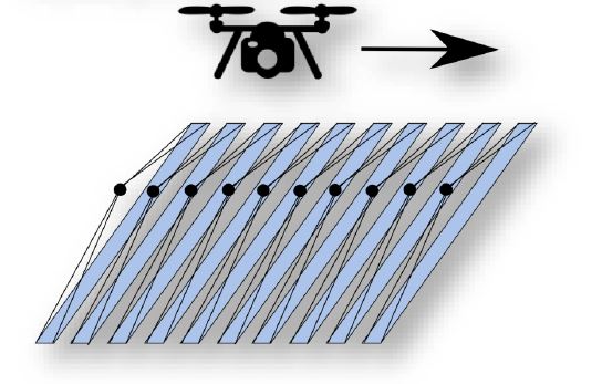
These different camera positions for each row are approximated by applying a linear interpolation between the two camera positions at the start and finish of the image readout. This linear approximation has been shown to work especially well with quadrotor gimbal drones that stabilize the camera to always face nadir. With Pix4D rolling shutter correction it is now possible to fly your drone at a faster speed without compromising the result accuracy. Since many consumer drones are equipped with rolling shutter cameras, this is a true enabler of professional mapping with consumer type drones.
Source: pix4d.com