Nowadays, an orthophoto mosaic is one of the most popular products of modern photogrammetry. It is a product that explicitly shows ground terrain and constructed buildings. With the development of digital technology, its preparation became more affordable and faster than preparation of a topographical map of comparable scale. For this reason, orthophoto imagery can be prepared more often, which make them much more current when compared to classic topographic maps.
Aerial photography is made according to the central projection principle, which means that certain geometric deformations occur when transforming the 3D world in a 2D image. Points that are on the same location in terms of position (horizontal), but on different heights, are mapped to different locations in the image. Furthermore, objects that are closed to the camera at the time of taking the image are displayed with a higher scale than more distant objects. This means that an aerial photography image is not correctly located in space in terms of position, and the image lacks a unified scale. Measurements of horizontal distances on aerial photographs are therefore not correct. Aerial photography deformations can be corrected with the orthorectification process, which gives us an orthophoto mosaic as the final product. This is done by using a digital relief model (DRM) to transform the aerial photographs taken using a central projection into an orthogonal projection.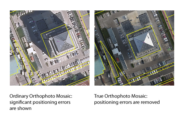 However, only those areas are correctly transformed in the orthorectification process that are defined in the DRM. This means that objects that are located above or below the terrain do not have the correct position and are not displayed in the correct size on the orthophoto. Distortions are greatest in the case of buildings, which are too large and tilted to the side away from the main point of the orthophoto, and in the case of bridges, which are bent downward, as they follow the contour of the terrain below them. To avoid or reduce problems as much as possible, we use the true orthophoto process.
A true orthophoto mosaic is an upgrade of the classic orthophoto. When creating a true orthophoto mosaic, we use a digital surface model (DSM) of sufficient quality. DSM also includes height information on objects above the surface. In aerial photography, a DSM usually includes buildings and bridges, in addition to terrain. In this case, buildings and bridges are transformed in the orthorectification process in the correct scale and onto the correct positions. Unlike a classic orthophoto, a true orthophoto allows us to measure horizontal distances also on edges of building roofs, enabling vectorisation of buildings, and, when used together with other vector layers, ensures a more correct positional matching.
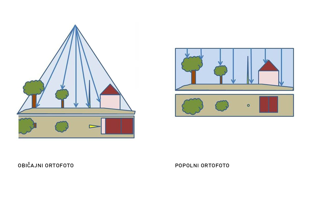
An important input data for preparing a true orthophoto mosaic is thus a quality DSM, which is created from the DRM with added information on the locations and heights of buildings and bridges. Heights of buildings can be obtained using multiple methods – building data can be captured manually from stereopairs, or we can use data from increasingly available laser scanning.