Deprecated: Redux_Class::__construct(): Implicitly marking parameter $redux as nullable is deprecated, the explicit nullable type must be used instead in /home/prod/domains/geavis.si/public_html/assets1191/wp-content/plugins/ronneby-core/inc/redux_framework/redux-core/inc/classes/class-redux-class.php on line 45
Deprecated: Redux_Filesystem::get_instance(): Implicitly marking parameter $me as nullable is deprecated, the explicit nullable type must be used instead in /home/prod/domains/geavis.si/public_html/assets1191/wp-content/plugins/ronneby-core/inc/redux_framework/redux-core/inc/classes/class-redux-filesystem.php on line 135
Deprecated: Redux_Filesystem::put_contents(): Implicitly marking parameter $perms as nullable is deprecated, the explicit nullable type must be used instead in /home/prod/domains/geavis.si/public_html/assets1191/wp-content/plugins/ronneby-core/inc/redux_framework/redux-core/inc/classes/class-redux-filesystem.php on line 528
Deprecated: Redux_Filesystem::chmod(): Implicitly marking parameter $perms as nullable is deprecated, the explicit nullable type must be used instead in /home/prod/domains/geavis.si/public_html/assets1191/wp-content/plugins/ronneby-core/inc/redux_framework/redux-core/inc/classes/class-redux-filesystem.php on line 667
Deprecated: Redux_Filesystem::mkdir(): Implicitly marking parameter $perms as nullable is deprecated, the explicit nullable type must be used instead in /home/prod/domains/geavis.si/public_html/assets1191/wp-content/plugins/ronneby-core/inc/redux_framework/redux-core/inc/classes/class-redux-filesystem.php on line 777
Deprecated: Redux_Filesystem::move_uploaded_file(): Implicitly marking parameter $perms as nullable is deprecated, the explicit nullable type must be used instead in /home/prod/domains/geavis.si/public_html/assets1191/wp-content/plugins/ronneby-core/inc/redux_framework/redux-core/inc/classes/class-redux-filesystem.php on line 972
Deprecated: Redux_Color_Scheme_Functions::get_field(): Implicitly marking parameter $redux as nullable is deprecated, the explicit nullable type must be used instead in /home/prod/domains/geavis.si/public_html/assets1191/wp-content/plugins/ronneby-core/inc/redux_framework/redux-core/inc/extensions/color_scheme/color_scheme/inc/class-redux-color-scheme-functions.php on line 211
Deprecated: Redux_Shortcodes::blog_info(): Implicitly marking parameter $content as nullable is deprecated, the explicit nullable type must be used instead in /home/prod/domains/geavis.si/public_html/assets1191/wp-content/plugins/ronneby-core/inc/redux_framework/redux-core/inc/extensions/shortcodes/class-redux-shortcodes.php on line 95
Deprecated: Redux_Shortcodes::theme_info(): Implicitly marking parameter $content as nullable is deprecated, the explicit nullable type must be used instead in /home/prod/domains/geavis.si/public_html/assets1191/wp-content/plugins/ronneby-core/inc/redux_framework/redux-core/inc/extensions/shortcodes/class-redux-shortcodes.php on line 149
Deprecated: Redux_Shortcodes::date(): Implicitly marking parameter $content as nullable is deprecated, the explicit nullable type must be used instead in /home/prod/domains/geavis.si/public_html/assets1191/wp-content/plugins/ronneby-core/inc/redux_framework/redux-core/inc/extensions/shortcodes/class-redux-shortcodes.php on line 205
Deprecated: WPML_Translations::__construct(): Implicitly marking parameter $wpml_cache as nullable is deprecated, the explicit nullable type must be used instead in /home/prod/domains/geavis.si/public_html/assets1191/wp-content/plugins/sitepress-multilingual-cms/classes/translations/class-wpml-translations.php on line 26
Deprecated: WPML_Translation_Element::__construct(): Implicitly marking parameter $wpml_cache as nullable is deprecated, the explicit nullable type must be used instead in /home/prod/domains/geavis.si/public_html/assets1191/wp-content/plugins/sitepress-multilingual-cms/classes/translations/class-wpml-translation-element.php on line 27 How does the senseFly eBee unmanned aircraft take off and land? – Geavis
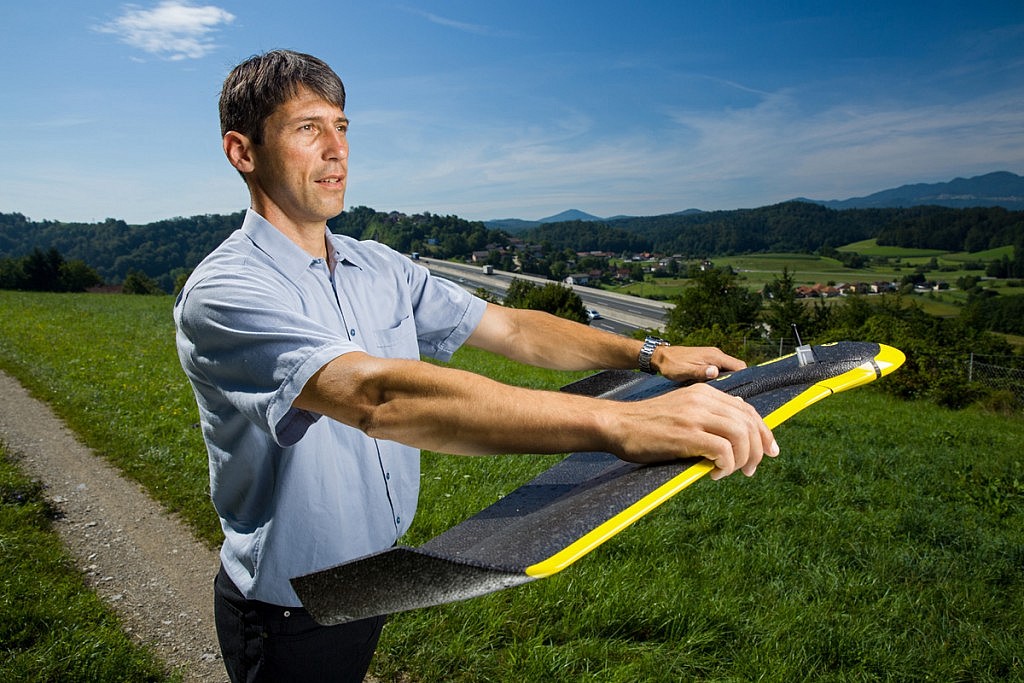
The senseFly eBee unmanned aircraft used by Geavis takes off from the operator’s hand after being directed against the wind in order to limit the necessary ground velocity. The aircraft’s software automatically determines the take-off point as well as the home waypoint, which is why the vicinity within a 40-metre radius around the take-off point must be free of hindrances that could obstruct landing.
The senseFly eBee unmanned aircraft used by Geavis takes off from the operator’s hand after being directed against the wind in order to limit the necessary ground velocity. The aircraft’s software automatically determines the take-off point as well as the home waypoint, which is why the vicinity within a 40-metre radius around the take-off point must be free of hindrances that could obstruct landing.
Although grass makes an ideal landing surface, eBee can also land safely on asphalt or other surfaces. The aircraft features low mass and is made of flexible material, and will not be irreparably damaged in the event of a hard landing. The only thing necessary to ensure is a landing area free of any prominent hindrances such as rocks, columns, trees, buildings etc.