+386 1 292 73 90info@geavis.si
SI
logo
Geavis
logo
  • Services
    • Spatial Data Acquisition
    • Advanced Spatial Data Processing
    • Geospatial Analysis
    • Visualizations and Presentations
  • Applications
    • Governmental Institutions and Public Sector
    • Real Estate
    • Mapping and Land Surveying
    • Civil Engineering
    • Industry and Infrastructure
    • Quarries and Open Mines
    • Agriculture and Forestry
    • Insurance
    • Spatial Research
    • Tourism and Promotion
  • Technology
  • Projects
  • Geavis
    • Geavis
    • Clients
    • Contact
  • Blog
SenseFly eBee user receives rare FAA exemption
Unmanned aircrafts in land surveying
How is aerial photography undertaken in hilly areas?
20.02.2015 Technology

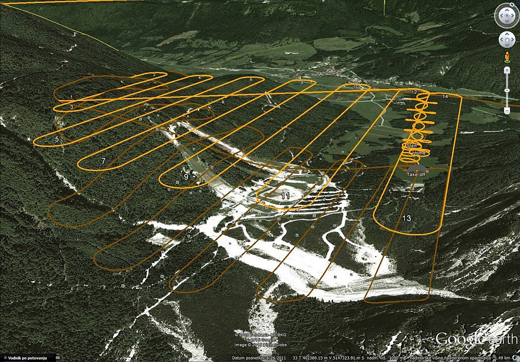
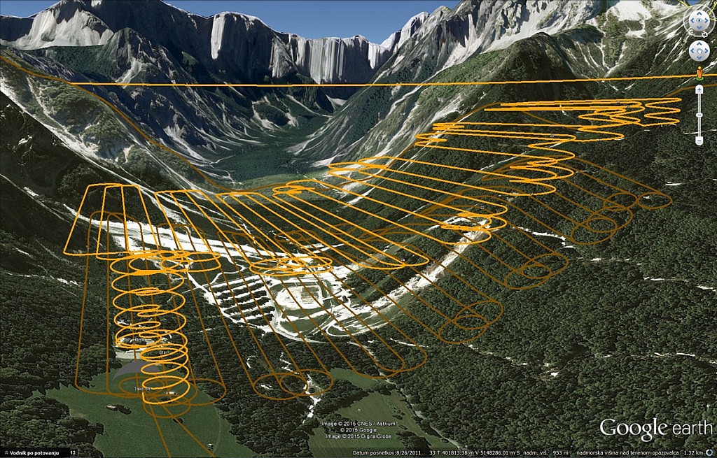
When it comes to aerial photography, hilly areas represent a special challenge. The camera acquires an image of the landscape in a fashion similar to that of the human eye in central projection, which is why more remote objects seem smaller than the nearby objects. This means that the photo’s resolution changes depending on the object’s distance from the camera.

In photogrammetric use of photos, it is important for the distance (height) of the camera from the terrain to be as constant as possible in all photos. This is the only way to obtain all aerial photos in the same resolution. For this reason, each unmanned aircraft flight is planned in advance, which means that the aircraft’s flight route is set above the area of which aerial photos need to be taken. In this process, we use public data available on the terrain which, in addition to the satellite image (Google Satellite, Microsoft Satellite, Mapbox Satellite), include the data of the digital terrain model (improved SRTM). Based on these data, the altitude is adjusted to each aerial photography route. During flight, the unmanned aircraft then changes its altitude in line with its planned route.

In addition to obtaining suitable aerial photos, the correct planning of the unmanned aircraft’s flight ensures the safety of said aircraft while taking aerial photos of a dynamic terrain.


0 Like!
Share
Leave a reply Required fields are marked *

Click here to cancel reply.

Categories

  • Agriculture and Forestry (4)
  • Mapping and Surveying (2)
  • Public Sector (1)
  • Quarries and Open Mines (2)
  • Real Estate (3)
  • Regulations (5)
  • Spatial Research (2)
  • Technology (40)
  • Trends (13)

Archive

  • January 2019 (1)
  • September 2018 (2)
  • June 2018 (1)
  • March 2018 (1)
  • January 2018 (2)
  • December 2017 (1)
  • September 2017 (1)
  • June 2017 (1)
  • May 2017 (2)
  • April 2017 (1)
  • March 2017 (1)
  • February 2017 (1)
  • January 2017 (3)
  • December 2016 (1)
  • November 2016 (1)
  • October 2016 (1)
  • September 2016 (2)
  • August 2016 (1)
  • July 2016 (2)
  • May 2016 (2)
  • April 2016 (1)
  • February 2016 (2)
  • January 2016 (1)
  • December 2015 (1)
  • November 2015 (1)
  • October 2015 (1)
  • September 2015 (2)
  • August 2015 (1)
  • July 2015 (2)
  • May 2015 (1)
  • April 2015 (1)
  • March 2015 (2)
  • February 2015 (3)
  • January 2015 (4)

GEOSPACE

Geospace is Geavis' collection of domestic and foreign web contents describing the adventures of those small civil unmanned drones, the application aspects of aerial photography and geospatial challenges for the benefit of life and business.


View my Flipboard Magazine.

Follow us

LinkedINYouTubeskype

BE INFORMED


We will not spam! Ever! You can unsubscribe any time.
© 2016 Geavis d.o.o.
  • | Cookies Information
  • | Legal Information
  • | Authors
Geavis