+386 1 292 73 90info@geavis.si
SI
logo
Geavis
logo
  • Services
    • Spatial Data Acquisition
    • Advanced Spatial Data Processing
    • Geospatial Analysis
    • Visualizations and Presentations
  • Applications
    • Governmental Institutions and Public Sector
    • Real Estate
    • Mapping and Land Surveying
    • Civil Engineering
    • Industry and Infrastructure
    • Quarries and Open Mines
    • Agriculture and Forestry
    • Insurance
    • Spatial Research
    • Tourism and Promotion
  • Technology
  • Projects
  • Geavis
    • Geavis
    • Clients
    • Contact
  • Blog
Archaeological heritage from the air
Civil Aviation Agency confirmed Geavis` Operations Manual
What does GSD tell and how is it related to the spatial resolution aerial photographs?
20.02.2016 Technology

Digital aerial photos are composed of a matrix of pixels. Each pixel is actually a small square. GSD (Ground Sample Distance) tells the size of the side of this square (representing one pixel) in natural size on the Earth’s surface. GSD value = 5cm means that each pixel shown on the aerial photo represents a line of 5cm on the ground or covers 25cm2 (5cm x 5cm) in the nature.Geavis-prostorska-locljivost-aerofotografij

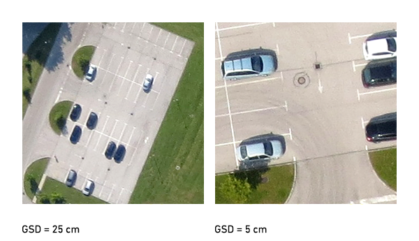
Spatial resolution of an aerial photography tells us to what extent the details can be recognized on aerial photography. Details smaller than the size of one pixel cannot be detected; to identify the matrix of at least 4×4 pixels is required. The greater the GSD value, the less visible are the details on the earth’s surface.

The GSD value and spatial resolution aerial photographs are closely related to the altitude of the drone flight. The higher it flies, the less the detail on the Earth’s surface are visible. By increasing the altitude of the flight the GSD value of the aerial photos is thus increasing and the spatial resolution decreases proportionally.

However, it may happen that in spite of flying at a constant altitude not all of the aerial photos obtained have the same GSD. This is due to the elevation of the terrain over which the drone is flying, and the inclination of the camera during shooting. These differences are later eliminated by using advanced processing algorithms. This ensures the orthophoto mosaic made from these aerial photographs to have unified GSD values at all spots.

4 Like!
Share
Leave a reply Required fields are marked *

Click here to cancel reply.

Categories

  • Agriculture and Forestry (4)
  • Mapping and Surveying (2)
  • Public Sector (1)
  • Quarries and Open Mines (2)
  • Real Estate (3)
  • Regulations (5)
  • Spatial Research (2)
  • Technology (40)
  • Trends (13)

Archive

  • January 2019 (1)
  • September 2018 (2)
  • June 2018 (1)
  • March 2018 (1)
  • January 2018 (2)
  • December 2017 (1)
  • September 2017 (1)
  • June 2017 (1)
  • May 2017 (2)
  • April 2017 (1)
  • March 2017 (1)
  • February 2017 (1)
  • January 2017 (3)
  • December 2016 (1)
  • November 2016 (1)
  • October 2016 (1)
  • September 2016 (2)
  • August 2016 (1)
  • July 2016 (2)
  • May 2016 (2)
  • April 2016 (1)
  • February 2016 (2)
  • January 2016 (1)
  • December 2015 (1)
  • November 2015 (1)
  • October 2015 (1)
  • September 2015 (2)
  • August 2015 (1)
  • July 2015 (2)
  • May 2015 (1)
  • April 2015 (1)
  • March 2015 (2)
  • February 2015 (3)
  • January 2015 (4)

GEOSPACE

Geospace is Geavis' collection of domestic and foreign web contents describing the adventures of those small civil unmanned drones, the application aspects of aerial photography and geospatial challenges for the benefit of life and business.


View my Flipboard Magazine.

Follow us

LinkedINYouTubeskype

BE INFORMED


We will not spam! Ever! You can unsubscribe any time.
© 2016 Geavis d.o.o.
  • | Cookies Information
  • | Legal Information
  • | Authors
Geavis