+386 1 292 73 90info@geavis.si
SI
logo
Geavis
logo
  • Services
    • Spatial Data Acquisition
    • Advanced Spatial Data Processing
    • Geospatial Analysis
    • Visualizations and Presentations
  • Applications
    • Governmental Institutions and Public Sector
    • Real Estate
    • Mapping and Land Surveying
    • Civil Engineering
    • Industry and Infrastructure
    • Quarries and Open Mines
    • Agriculture and Forestry
    • Insurance
    • Spatial Research
    • Tourism and Promotion
  • Technology
  • Projects
  • Geavis
    • Geavis
    • Clients
    • Contact
  • Blog
What UAV to choose? Fixed wing or rotary drone?
What does GSD tell and how is it related to the spatial resolution aerial photographs?
Archaeological heritage from the air
15.02.2016 Spatial Research

For scientific projects and research of archaeological heritage, a comprehensive overview of the landscape and its elements is essential. It is also useful to have a look from different perspectives on the area in question. At the same time, it is very important not to interfere with or affect the environment in which your research work is conducted.

Geavis-arheoloska-dediscina-iz-zraka

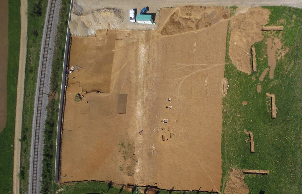
Thanks to the remote sensing engineering, researchers have access to advanced and non-destructive methods of obtaining spatial data. For these matters, the most established methods include aerial photography and LIDAR earth surface laser scanning. Since it never disrupts the environment, a small drone is the most appropriate means of support for such projects. Even in sensitive areas, its low weight, flexible materials, low speeds and absence of  noise allow the drones taking off and landing without making any damage to the environment. In the heavily forested Slovenia, LIDAR technology is of a paramount importance. It enables accurate measuring of the earth’s surface including all vestiges of the past hidden under vegetation cover. Obtaining data from laser scanning makes especially sense when investigating large areas of overgrown terrain, where aerial photography cannot penetrate through the vegetation of the earth’s surface.

Most of the archaeological sites become visible through the colour symbols (e.g. underground), or signs of vegetation (e.g. differences in growth and ripening of crops) and when specific conditions are present, such as drought, floods, low light, or a certain level of plant growth. Our professional interpretation of aerial photographs enables easier detecting of changes and deviations in the landscape possibly identifying new archaeological sites. Even more. Preforming cyclic recording we monitor their conditions and changes in their environment. As a result, their placement and role in the region are much better understood and, as a consequence, they are better protected against reckless interventions.

3 Like!
Share
Leave a reply Required fields are marked *

Click here to cancel reply.

Categories

  • Agriculture and Forestry (4)
  • Mapping and Surveying (2)
  • Public Sector (1)
  • Quarries and Open Mines (2)
  • Real Estate (3)
  • Regulations (5)
  • Spatial Research (2)
  • Technology (40)
  • Trends (13)

Archive

  • January 2019 (1)
  • September 2018 (2)
  • June 2018 (1)
  • March 2018 (1)
  • January 2018 (2)
  • December 2017 (1)
  • September 2017 (1)
  • June 2017 (1)
  • May 2017 (2)
  • April 2017 (1)
  • March 2017 (1)
  • February 2017 (1)
  • January 2017 (3)
  • December 2016 (1)
  • November 2016 (1)
  • October 2016 (1)
  • September 2016 (2)
  • August 2016 (1)
  • July 2016 (2)
  • May 2016 (2)
  • April 2016 (1)
  • February 2016 (2)
  • January 2016 (1)
  • December 2015 (1)
  • November 2015 (1)
  • October 2015 (1)
  • September 2015 (2)
  • August 2015 (1)
  • July 2015 (2)
  • May 2015 (1)
  • April 2015 (1)
  • March 2015 (2)
  • February 2015 (3)
  • January 2015 (4)

GEOSPACE

Geospace is Geavis' collection of domestic and foreign web contents describing the adventures of those small civil unmanned drones, the application aspects of aerial photography and geospatial challenges for the benefit of life and business.


View my Flipboard Magazine.

Follow us

LinkedINYouTubeskype

BE INFORMED


We will not spam! Ever! You can unsubscribe any time.
© 2016 Geavis d.o.o.
  • | Cookies Information
  • | Legal Information
  • | Authors
Geavis