+386 1 292 73 90info@geavis.si
SI
logo
Geavis
logo
  • Services
    • Spatial Data Acquisition
    • Advanced Spatial Data Processing
    • Geospatial Analysis
    • Visualizations and Presentations
  • Applications
    • Governmental Institutions and Public Sector
    • Real Estate
    • Mapping and Land Surveying
    • Civil Engineering
    • Industry and Infrastructure
    • Quarries and Open Mines
    • Agriculture and Forestry
    • Insurance
    • Spatial Research
    • Tourism and Promotion
  • Technology
  • Projects
  • Geavis
    • Geavis
    • Clients
    • Contact
  • Blog
Acquire more data and in a more safe manner
What happens to a small unmanned aerial vehicle in case of an empty battery or loss of the GPS signal?
05.01.2015 Technology

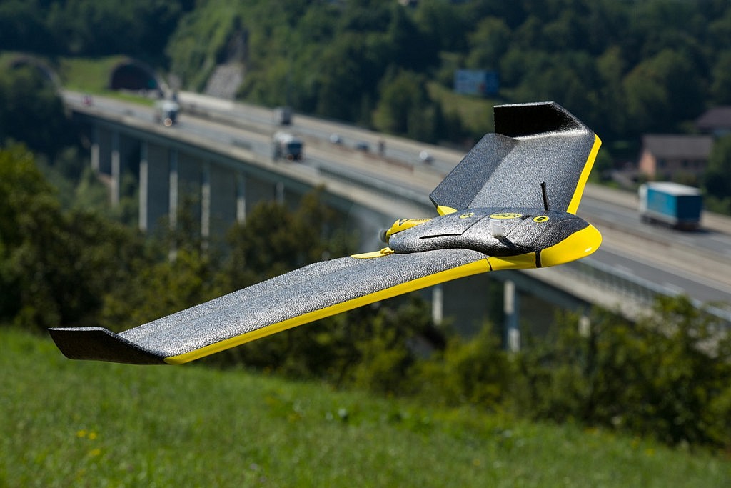
Critical situations of the unmanned aerial vehicle occur extremely rarely. SenseFly eBee unmanned aerial vehicle used by Geavis will try to return to its take-off location and to land safely before its battery will get empty. In the unlikely event that the reception of the GPS signal fails, a normal navigation is no longer possible. To reduce the risk of injuries and endangering the surroundings, the flight function of SenseFly eBee unmanned aerial vehicle will immediately switch to land mode in a typical circular flight pattern at low speed. If the reception of the GPS signal is restored, SenseFly eBee aerial vehicle can also establish its own navigation and return to its take-off location.

The sensors of aerial vehicle report at all times on all its vital functions in order that its position, altitude, speed, and battery status may be controlled by the operator. The autopilot takes care of the flights through the planned track, by activating the camera and data logging of GPS / IMU. The operator can thus focus all its attention to the flight control and, if necessary, respond immediately by changing the planned flight. Low weight (600 g), flexible material, and low speeds thus present minimal and negligible risk of injuries in case of a possible collision of the aerial vehicle.
_40A9025r

0 Like!
Share
Leave a reply Required fields are marked *

Click here to cancel reply.

Categories

  • Agriculture and Forestry (4)
  • Mapping and Surveying (2)
  • Public Sector (1)
  • Quarries and Open Mines (2)
  • Real Estate (3)
  • Regulations (5)
  • Spatial Research (2)
  • Technology (40)
  • Trends (13)

Archive

  • January 2019 (1)
  • September 2018 (2)
  • June 2018 (1)
  • March 2018 (1)
  • January 2018 (2)
  • December 2017 (1)
  • September 2017 (1)
  • June 2017 (1)
  • May 2017 (2)
  • April 2017 (1)
  • March 2017 (1)
  • February 2017 (1)
  • January 2017 (3)
  • December 2016 (1)
  • November 2016 (1)
  • October 2016 (1)
  • September 2016 (2)
  • August 2016 (1)
  • July 2016 (2)
  • May 2016 (2)
  • April 2016 (1)
  • February 2016 (2)
  • January 2016 (1)
  • December 2015 (1)
  • November 2015 (1)
  • October 2015 (1)
  • September 2015 (2)
  • August 2015 (1)
  • July 2015 (2)
  • May 2015 (1)
  • April 2015 (1)
  • March 2015 (2)
  • February 2015 (3)
  • January 2015 (4)

GEOSPACE

Geospace is Geavis' collection of domestic and foreign web contents describing the adventures of those small civil unmanned drones, the application aspects of aerial photography and geospatial challenges for the benefit of life and business.


View my Flipboard Magazine.

Follow us

LinkedINYouTubeskype

BE INFORMED


We will not spam! Ever! You can unsubscribe any time.
© 2016 Geavis d.o.o.
  • | Cookies Information
  • | Legal Information
  • | Authors
Geavis