+386 1 292 73 90info@geavis.si
SI
logo
Geavis
logo
  • Services
    • Spatial Data Acquisition
    • Advanced Spatial Data Processing
    • Geospatial Analysis
    • Visualizations and Presentations
  • Applications
    • Governmental Institutions and Public Sector
    • Real Estate
    • Mapping and Land Surveying
    • Civil Engineering
    • Industry and Infrastructure
    • Quarries and Open Mines
    • Agriculture and Forestry
    • Insurance
    • Spatial Research
    • Tourism and Promotion
  • Technology
  • Projects
  • Geavis
    • Geavis
    • Clients
    • Contact
  • Blog
What happens to a small unmanned aerial vehicle in case of an empty battery or loss of the GPS signal?
Point cloud fly-through animation
Acquire more data and in a more safe manner
08.01.2015 Quarries and Open Mines

Kamnolom_ortofoto

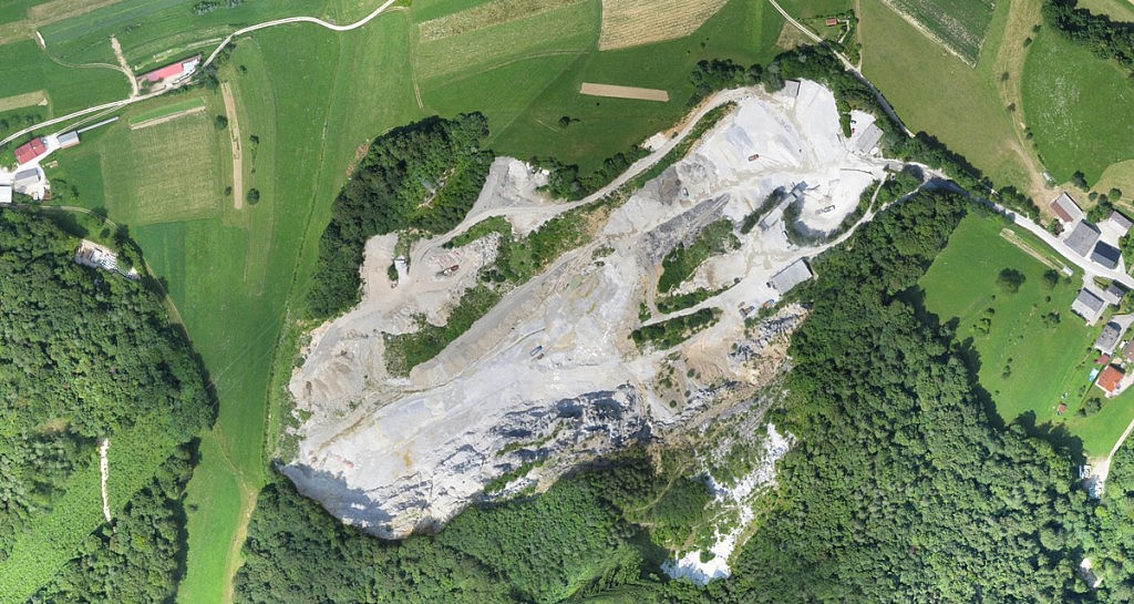
Numerous problems that are facing the experts in the field of excavation in quarries, sand pits and gravel pits can be solved by using the data collected via the aerial photos. This approach provides you with high-quality spatial information, reduces the need for field work, enables faster results, and reduces costs. The geodetic measurements, that have recently required several days or weeks by using the traditional techniques, can now be carried out in just a few hours. The procedure is fast and non-intrusive for the work processes in the quarry, without interrupting the work.

By conducting the unmanned aerial vehicle at low altitudes, we can obtain sharp aerial photographs of resolution of 2 to 5 cm/px from which every detail of the terrain is made visible. Based on the aerial photographs with advanced processing and analysis it is then possible to carry out:

  • dense 3D point cloud
  • orthophoto plans
  • 3D digital terrain model
  • measurements of surfaces, volumes, distances and heights of excavated or bulk material
  • measurements of geometric features of the facilities and their identification in the photos

Moreover, the periodic aerial photography helps us to monitor and document the changes in your area, and the data obtained can be compared with a previous situation, which can benefit you in capacity planning, inventory monitoring, organizing and re-greening of the abandoned quarries, etc.


0 Like!
Share
Leave a reply Required fields are marked *

Click here to cancel reply.

Categories

  • Agriculture and Forestry (4)
  • Mapping and Surveying (2)
  • Public Sector (1)
  • Quarries and Open Mines (2)
  • Real Estate (3)
  • Regulations (5)
  • Spatial Research (2)
  • Technology (40)
  • Trends (13)

Archive

  • January 2019 (1)
  • September 2018 (2)
  • June 2018 (1)
  • March 2018 (1)
  • January 2018 (2)
  • December 2017 (1)
  • September 2017 (1)
  • June 2017 (1)
  • May 2017 (2)
  • April 2017 (1)
  • March 2017 (1)
  • February 2017 (1)
  • January 2017 (3)
  • December 2016 (1)
  • November 2016 (1)
  • October 2016 (1)
  • September 2016 (2)
  • August 2016 (1)
  • July 2016 (2)
  • May 2016 (2)
  • April 2016 (1)
  • February 2016 (2)
  • January 2016 (1)
  • December 2015 (1)
  • November 2015 (1)
  • October 2015 (1)
  • September 2015 (2)
  • August 2015 (1)
  • July 2015 (2)
  • May 2015 (1)
  • April 2015 (1)
  • March 2015 (2)
  • February 2015 (3)
  • January 2015 (4)

GEOSPACE

Geospace is Geavis' collection of domestic and foreign web contents describing the adventures of those small civil unmanned drones, the application aspects of aerial photography and geospatial challenges for the benefit of life and business.


View my Flipboard Magazine.

Follow us

LinkedINYouTubeskype

BE INFORMED


We will not spam! Ever! You can unsubscribe any time.
© 2016 Geavis d.o.o.
  • | Cookies Information
  • | Legal Information
  • | Authors
Geavis