+386 1 292 73 90info@geavis.si
SI
logo
Geavis
logo
  • Services
    • Spatial Data Acquisition
    • Advanced Spatial Data Processing
    • Geospatial Analysis
    • Visualizations and Presentations
  • Applications
    • Governmental Institutions and Public Sector
    • Real Estate
    • Mapping and Land Surveying
    • Civil Engineering
    • Industry and Infrastructure
    • Quarries and Open Mines
    • Agriculture and Forestry
    • Insurance
    • Spatial Research
    • Tourism and Promotion
  • Technology
  • Projects
  • Geavis
    • Geavis
    • Clients
    • Contact
  • Blog
  • All
  • Agriculture and Forestry
  • Civil Engineering
  • Governmental Institutions and Public Sector
  • Mapping and Surveying
  • Quarries and Open Mines
  • Real Estate
  • Spatial Research
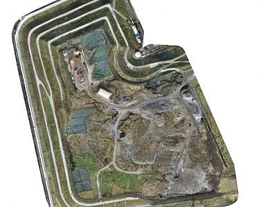
Photogrammetric measuring of landfill cells at the Barje landfill
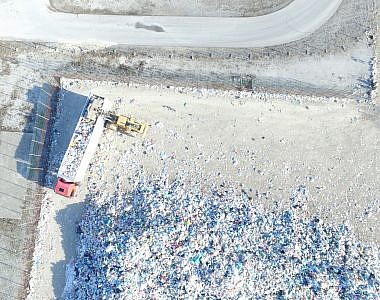
Calculating the volume of waste fractions at the Ljubljana Regional Waste Management Centre
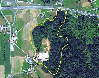
Photogrammetric documentation of the archaeological site in Muljava
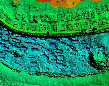
LiDAR data leading to archaeological sites in the area of Ivančna Gorica

GEOSPACE

Geospace is Geavis' collection of domestic and foreign web contents describing the adventures of those small civil unmanned drones, the application aspects of aerial photography and geospatial challenges for the benefit of life and business.


View my Flipboard Magazine.

Follow us

LinkedINYouTubeskype

BE INFORMED


We will not spam! Ever! You can unsubscribe any time.
© 2016 Geavis d.o.o.
  • | Cookies Information
  • | Legal Information
  • | Authors
Geavis